THE HIGH ANDES TO THE HIGH SEAS:
A TRANSANDEAN EXPEDITION TO THE NATIONAL PARKS OF NORTHWESTERN ARGENTINA ,
THE ATACAMA DESERT, AND EASTER ISLAND
March 19-April 9, 2008
22 Days/21 Nights
Carol and Carlos Passera, Barbara Knapton, and Audrey Benedict
Few journeys can compare with the spectacular landscapes and natural and cultural diversity we’ll experience as we travel the ancient Inca Road (the Ohapaq-Ñan) across the high Andes of Argentina and Chile.This extraordinary expedition will explore several of the most important of UNESCO’s World Heritage Sites, beginning in the Andean altiplano and Yungas cloudforests of northwestern Argentina (Los Cordones National Park and Calilegua National Park) and continuing on to embrace the stark beauty of Chile’s Atacama Desert and the volcano-dotted wonderland of Lauca National Park. We’ll conclude this once-in-a-lifetime journey with four days spent exploring one the most hauntingly beautiful places on Earth—the Chilean outpost of Easter Island.
 We begin our journey in northwestern Argentina, with a flight from Buenos Aires to the colonial city of Salta, with its dramatic backdrop of 16,000-foot peaks. Exploring the saguaro-like cactus forests of Los Cordones National Park, we’ll travel the unpaved road that climbs to 11,000 feet and then drops down into the unique forests of the Tin-Tin and the exquisitely beautiful Valle Encantado. We’ll be continually watching for wildlife—herds of guanacos, Andean condors, Aplomado falcons, Andean foxes, mountain vizcachas (members of the chinchilla family), and birds such as the red-tailed comet and the giant hummingbird, to name just a few. We begin our journey in northwestern Argentina, with a flight from Buenos Aires to the colonial city of Salta, with its dramatic backdrop of 16,000-foot peaks. Exploring the saguaro-like cactus forests of Los Cordones National Park, we’ll travel the unpaved road that climbs to 11,000 feet and then drops down into the unique forests of the Tin-Tin and the exquisitely beautiful Valle Encantado. We’ll be continually watching for wildlife—herds of guanacos, Andean condors, Aplomado falcons, Andean foxes, mountain vizcachas (members of the chinchilla family), and birds such as the red-tailed comet and the giant hummingbird, to name just a few.
Leaving the cactus forests of the Andean Altiplano, we’ll shift our attention to the mistshrouded, epiphyte-laden Yungas cloudforests preserved within the Reserva del Huaico and Calilegua National Park. Among the most threatened of all Andean forest ecosytems, the Yungas cloudforests occupy only 2% of Argentina but support nearly 50% of the country’s biodiversity— colorful subtropical species such as the black-and-chestnut eagle, golden-collared macaw, blue-crowned trogon, plush-crested jay, and redthroated dipper. We’ll walk forest trails looking for mammal tracks and, hopefully, for a glimpse of the elusive jaguar, a troop of capuchin monkeys, northern Andean deer, tapirs, crab-eating foxes, or the rare little “marsupial” frog that broods its young in a pouch.
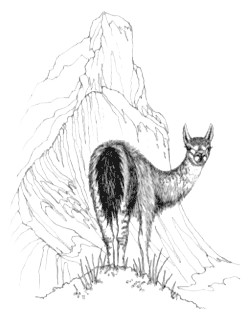
Our route continues along the Camino Inca, through the colorful valley known as the Quebrada de Humahuaca (a World Heritage Site) and on to the archaeological site of Pucara de Tilcara. The mountain villages that dot the hillsides here remind us that we are in the heartland of the hardy Quechua Indians—the realm of Pachamama, the “earth goddess.” Traveling over Jama Pass, we’ll pass colorful cliffs, puna grasslands, and deep-blue lagoons—always watching for vicuñas, the delicate little cousin of the llama, brush-tailed vizcachas, the highland tuco-tuco, and possibly even the rare Andean cat, which resembles a miniature snow leopard.
Atacama Salt Lagoons
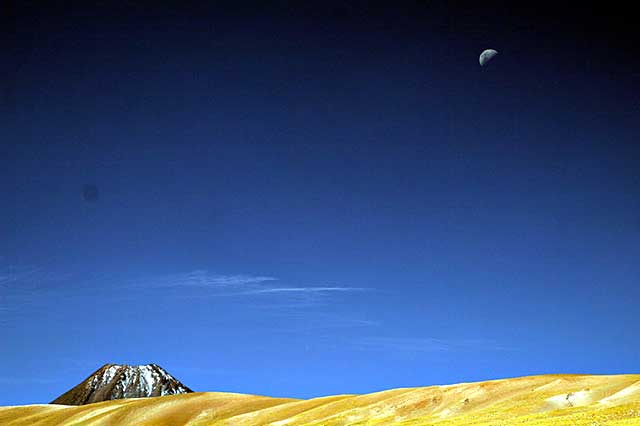
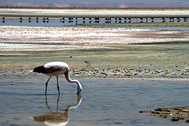
Arriving at the oasis of San Pedro de Atacama, we’ll see before us the spectacular moonscape of the Atacama Desert, a vast expanse stretching 600 miles from northern Chile to Peru’s southern border. We’ll spend several days exploring the Atacama’s natural and geologic wonders as well as the archaeological treasures left behind by pre- Inca and Inca cultures. Set against a backdrop of 20,000-ft. high, snow-capped volcanoes, the Atacama Desert is considered the driest place on earth. Except during rare El Niño years, the only consistent moisture comes from the dense coastal fog, the camanchaca. This life-giving fog nourishes unique plant communities called lomas, which contain a surprising diversity of plants. Near Chungungo, human “fog-catchers” string fine-meshed nets directly in the path of the camanchaca, capturing what moisture condenses on the nets and diverting it to their village. A visit to Salar de Atacama and Chaxa Lagoon will reward us with superb looks at all three species of South American flamingos: Chilean, Andean, and the rare Puna. Traveling up to 13,800 feet to experience the eruption of the El Tatio geysers will add one more stunning contrast to our journey.
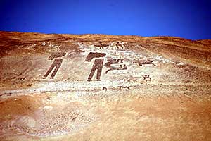 Arica Geogliphs
After flying to Arica, we’ll enjoy our beachfront resort and bird along the rocky coastline for elegant and Inca terns, gray gulls, Peruvian pelicans and boobies, the Chilean woodstar, the oasis hummingbird, and many other species. Driving on to Putre, which was founded in 1580, we’ll visit the Museo Arqueológico San Miguel, where the pre-Inca mummies from the Atacama are on exhibit, and the huge geoglyph site near San Miguel de Azapa. Wherever we look, ancient lineages are reflected in the faces and in the bright wool ponchos and shawls of the indigenous residents. Our final three days on the mainland will be spent exploring one of South America’s most spectacular parks—Lauca National Park. The 19,700-ft high volcanoes Parinacota and Pomerate and the emerald waters of Laguna Cotacotani and Lago Chungará dominate the alpine landscape here. Lago Chungará, a UNESCO Biosphere Reserve and one of the highest lakes in the world, teems with unusual wildlife—giant coots, Andean geese, puna ibis, the flightless tagua-tagua, puna snipe, torrent ducks, and all three species of flamingos.
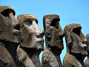 Easter Island, a UNESCO World Heritage Site, is one of the most haunting and mysterious places on earth. Located 2,300 miles west of the Chilean coast, this volcano-dotted island is the most remote inhabited island in the world. The mysteries of Easter Island and its indigenous inhabitants, the Rapanui, have intrigued archaeologists and travelers for centuries.The famous voyage of Thor Heyerdahl’s raft, Kon-Tiki, focused world attention on the gigantic stone statues, or moai,which can be seen all over the island. Most of the stone statues (and there are hundreds) depict a highlystylized male torso and head, some topped with a huge red stone cylinder, and standing about 15 to 20 feet tall; the largest is 70 feet tall and weighs about 270 tons. Organizing the carving, transport, and erection of these immense statues required a complex, populous society living in an environment rich enough to support it. Archaeologists now believe that Easter Island was colonized aroundA.D. 900 by Polynesians from the Marquesa Islands or Mangareva. We’ll spend four fascinating days touring Easter Island, visiting all of the island’s important archaeological sites. The environmental lessons of Easter Island—overpopulation, resource depletion and deforestation, warfare, famine, cannibalism, and cultural collapse— are especially troubling. We have taken great care to plan an amazing expedition and encourage you to register without delay! Easter Island, a UNESCO World Heritage Site, is one of the most haunting and mysterious places on earth. Located 2,300 miles west of the Chilean coast, this volcano-dotted island is the most remote inhabited island in the world. The mysteries of Easter Island and its indigenous inhabitants, the Rapanui, have intrigued archaeologists and travelers for centuries.The famous voyage of Thor Heyerdahl’s raft, Kon-Tiki, focused world attention on the gigantic stone statues, or moai,which can be seen all over the island. Most of the stone statues (and there are hundreds) depict a highlystylized male torso and head, some topped with a huge red stone cylinder, and standing about 15 to 20 feet tall; the largest is 70 feet tall and weighs about 270 tons. Organizing the carving, transport, and erection of these immense statues required a complex, populous society living in an environment rich enough to support it. Archaeologists now believe that Easter Island was colonized aroundA.D. 900 by Polynesians from the Marquesa Islands or Mangareva. We’ll spend four fascinating days touring Easter Island, visiting all of the island’s important archaeological sites. The environmental lessons of Easter Island—overpopulation, resource depletion and deforestation, warfare, famine, cannibalism, and cultural collapse— are especially troubling. We have taken great care to plan an amazing expedition and encourage you to register without delay!
Price: $8,450 (includes a $1000 deposit)
Group Size: 14 Trip Rating: 3
Price Includes: expert naturalist and archaeological guides throughout, 21 nights’ lodging, all internal flights (Buenos Aires to Salta, Antofagasta to Arica, and Arica to Santiago), the roundtrip 5- hour flight to Easter Island from Santiago, all ground transportation (van and small bus), all meals, all park entrance fees, and all gratuities. Does not include alcohol, items of a personal nature, or roundtrip transportation from your home airport (to Buenos Aires on March 19 and returning from Santiago on April 9).
photos on this page (except Easter Island Statue)
by Carlos Passera |